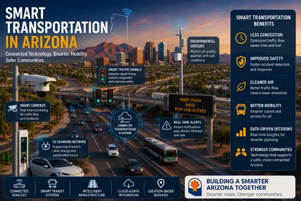
Connected public transit in Arizona is becoming a practical part of the state’s smart transportation future. As cities grow, commute patterns change, event districts expand, and more residents need reliable mobility options, transit agencies and local governments are using data, GPS, apps, connected vehicles, smart fare systems, and real-time alerts to make transit easier to use.
In metro Phoenix, Valley Metro already provides regional bus and light rail services, and its tools include trip planning, Smart Fare, and real-time bus and light rail location features. Valley Metro
Most transit articles focus only on buses and trains. Connected public transit is bigger than that. It is the digital layer that helps people understand where transit is, when it is coming, how to pay, how to transfer, and how to connect with other transportation options.
In Arizona, connected transit can help solve practical mobility problems:
- Making bus and light rail arrivals more predictable
- Improving access for riders without cars
- Supporting seniors, students, workers, and people with disabilities
- Connecting fixed-route transit with microtransit
- Improving event transportation and crowd movement
- Reducing uncertainty during extreme heat
- Helping cities plan routes based on real rider data
- Connecting transit with smart transportation and public safety systems
Connected public transit uses digital systems, sensors, GPS, mobile apps, fare technology, vehicle data, and communication networks to improve the rider and operator experience. Instead of treating transit as a fixed schedule printed on a sign, connected transit creates a live transportation system that updates in real time.
| Connected Transit Feature |
How It Works |
Arizona Use Case |
| Real-Time Arrival Data |
Uses GPS to estimate bus and train arrival times |
Helps riders avoid long waits in heat |
| Smart Fare Systems |
Allows digital payment, fare capping, and account-based rides |
Simplifies payment for frequent and occasional riders |
| Transit Apps |
Provides trip planning, route updates, and service alerts |
Supports bus, light rail, and multimodal trips |
| Vehicle Telematics |
Tracks vehicle health, location, speed, and service performance |
Improves fleet maintenance and reliability |
| Microtransit Platforms |
Uses app-based or phone-based on-demand rides in service zones |
Supports areas with limited fixed-route transit |
| Passenger Information Displays |
Shows arrivals, delays, and alerts at stations or stops |
Improves rider confidence at busy transit points |
Arizona has a transportation challenge that is different from older dense cities. Many communities are spread out, summer heat makes waiting uncomfortable or unsafe, and growth is creating new travel patterns in suburban and industrial areas.
Connected transit can help riders make better decisions. Knowing that a bus is 4 minutes away instead of guessing from a static schedule changes the rider experience. Real-time information is especially valuable during heat, service delays, road construction, large events, and transfers.
Valley Metro notes that buses and trains are equipped with GPS technology, allowing riders to access real-time scheduled arrival times through NextRide. Valley Metro NextRide
Real-time transit data is one of the most important parts of connected public transit. When buses and trains share location data, riders can see whether a vehicle is on time, delayed, or approaching.
Real-time data helps:
- Reduce uncertainty
- Improve transfer planning
- Support better dispatch decisions
- Improve customer communication
- Help agencies measure service reliability
- Support third-party trip planning tools
This connects directly with Smart Transportation in Arizona, because public transit becomes more useful when it shares data with broader mobility systems.
Smart fare systems can make transit easier for:
- Daily commuters
- Students
- Visitors
- Event attendees
- Low-income riders
- People who use multiple routes
The value is not just digital payment. The value is reducing friction. When payment is easier, riders are more likely to use the system confidently.
Arizona heat makes transit reliability more than a convenience issue. Riders waiting at unsheltered stops during summer need accurate arrival information, shaded infrastructure, service alerts, and better communication.
Connected transit can support heat-aware mobility through:
- Real-time arrival information
- Alerts about delays before riders leave home
- Smart shelters with shade and lighting
- Temperature monitoring at high-use stops
- Passenger information displays at major stations
- Connections to cooling center information during heat emergencies
Related reading: Emergency Notification Systems in Arizona
Microtransit is becoming an important option in Arizona communities where traditional fixed-route service may not fully meet local needs. Microtransit usually works like an on-demand shared ride service within a defined zone. Riders may request service through an app or phone call, and vehicles pick up passengers at virtual stops or designated areas.
Valley cities including Avondale and Glendale have used microtransit programs to improve local mobility in areas with limited traditional transit access. Axios Phoenix microtransit coverage
Microtransit can be especially useful for:
- First-mile and last-mile connections
- Suburban neighborhoods
- Seniors and riders with limited mobility
- Students
- Employment centers not directly served by fixed routes
- Communities with lower transit density
Public transit is a major part of smart city planning. A city cannot be truly smart if residents cannot move efficiently, affordably, and safely. Connected transit data helps cities understand travel demand, access gaps, service delays, and rider needs.
Connected transit also works with smart traffic signals, smart cameras, emergency alerts, air quality monitoring, and EV infrastructure.
Related category: Smart Cities & Government
Related reading: How Phoenix Is Becoming a Smart City
Transit systems are public spaces, so safety matters. Connected public transit can support public safety through cameras, emergency communication, driver alerts, station monitoring, vehicle location data, and faster incident reporting.
Transit safety systems may include:
- Connected cameras on vehicles and platforms
- Emergency call buttons
- Operator communication tools
- Vehicle location sharing with dispatch
- Service disruption alerts
- Passenger information during emergencies
Related reading: Public Safety IoT in Arizona
Related reading: Smart Cameras in Arizona
Public transit electrification is another part of connected mobility. Electric buses, charging depots, smart chargers, and energy management systems require data coordination between transit agencies, utilities, fleet managers, and maintenance teams.
EV transit operations require monitoring:
- Battery state of charge
- Charging schedules
- Route energy use
- Charger availability
- Vehicle range
- Grid demand
- Maintenance needs
Related reading: EV Charging Infrastructure in Arizona
Related reading: Smart Electric Grids in Arizona
Buses, paratransit vehicles, microtransit vans, maintenance vehicles, and support fleets all benefit from telematics. Fleet data helps agencies monitor vehicle location, maintenance needs, fuel or energy use, driver safety, and schedule performance.
Related reading: Fleet Telematics in Arizona
| City |
Connected Transit Opportunity |
Internal Link |
| Phoenix |
Real-time bus and light rail data, airport connections, heat-aware rider tools, event mobility |
Logistics & Transportation in Phoenix |
| Tempe |
Campus mobility, light rail access, pedestrian corridors, app-based rider communication |
Logistics & Transportation in Tempe |
| Mesa |
Light rail extension areas, growth corridors, bus reliability, service alerts |
Logistics & Transportation in Mesa |
| Glendale |
Microtransit, event districts, sports venue mobility, parking and shuttle coordination |
Logistics & Transportation in Glendale |
| Chandler |
Employment center access, microtransit, commute planning, technology corridor mobility |
Logistics & Transportation in Chandler |
| Scottsdale |
Tourism mobility, resort workforce transportation, event shuttles, parking coordination |
Logistics & Transportation in Scottsdale |
| Goodyear |
First-mile and last-mile access, warehouse workforce mobility, suburban microtransit |
Logistics & Transportation in Goodyear |
| Gilbert |
Residential growth, commuter connections, school and family mobility planning |
Logistics & Transportation in Gilbert |
| Tucson |
University-area mobility, bus data, regional route planning, heat-aware rider communication |
Logistics & Transportation in Tucson |
| Rider Need |
Connected Transit Solution |
| Knowing when the bus arrives |
Real-time GPS arrival predictions |
| Paying without confusion |
Smart fare accounts and mobile payment |
| Avoiding missed transfers |
Trip planning and live service updates |
| Staying informed during delays |
Push alerts, signage, and service notices |
| Reaching areas outside fixed routes |
Microtransit and first-mile/last-mile connections |
| Feeling safer |
Cameras, emergency communication, and better station visibility |
Connected transit also helps the agencies and cities that operate transportation systems. Data from vehicles, riders, payments, stops, routes, and service alerts can improve planning and operations.
- Better route performance analysis
- Improved schedule reliability
- More accurate ridership data
- Faster service disruption communication
- Better maintenance planning
- Improved accessibility planning
- More informed transit investment decisions
Connected transit creates opportunity, but implementation must be thoughtful. Technology alone does not fix transit access if service frequency, coverage, shade, safety, and affordability are not addressed.
- Reliable data quality
- Mobile access for riders without smartphones
- Language accessibility
- Heat-safe stop design
- Privacy and data governance
- Cybersecurity for fare and vehicle systems
- Coordination between cities and agencies
- Funding for maintenance and upgrades
- Only building an app: Connected transit must improve real service, not just the user interface.
- Ignoring riders without smartphones: Text tools, signage, call centers, and printed information still matter.
- Skipping heat resilience: Real-time arrivals help, but shade and safe waiting areas are still essential.
- Not integrating with smart transportation: Transit should connect with traffic signals, alerts, and city dashboards.
- Collecting data without acting on it: Ridership and delay data should guide planning decisions.
Connected public transit depends on semiconductors, sensors, GPS, mobile software, fare systems, cameras, cloud platforms, edge computing, cybersecurity, and public safety technology. Arizona’s broader IoT ecosystem includes companies connected to many of these enabling technologies.
The future of connected public transit in Arizona will likely include more real-time data, more microtransit, smarter fare systems, better rider alerts, EV bus infrastructure, AI-assisted service planning, and stronger integration with smart city platforms.
The most valuable systems will not simply produce more transit data. They will help riders make better trips and help agencies make better decisions.
Connected public transit in Arizona is about making mobility more visible, reliable, and usable. Real-time arrival data, smart fare systems, transit apps, GPS-enabled vehicles, microtransit, EV buses, and public safety integrations can help Arizona cities serve riders more effectively.
For a state shaped by growth, heat, long distances, and changing commute patterns, connected transit is not just a technology upgrade. It is part of building a more accessible and resilient transportation system.
Frequently asked questions
Connected public transit uses GPS, mobile apps, smart fare systems, vehicle data, alerts, and digital platforms to improve transit reliability, rider communication, and operations.
It is important because Arizona cities are growing, trips can be spread out, heat affects waiting conditions, and riders need better real-time information.
Yes. Valley Metro buses and trains use GPS technology, and riders can access real-time arrival information through tools such as NextRide.
Smart Fare is a digital fare system that allows riders to load an account, scan when riding, and benefit from fare caps.
Microtransit is an on-demand shared transportation service that usually operates within a defined zone and can support first-mile and last-mile mobility.
Related articles


 Logistics & Transportation